Icicle Creek is a magical happy place. 😀

Entering the narrow canyon between Icicle Ridge and Cashmere Mountain.
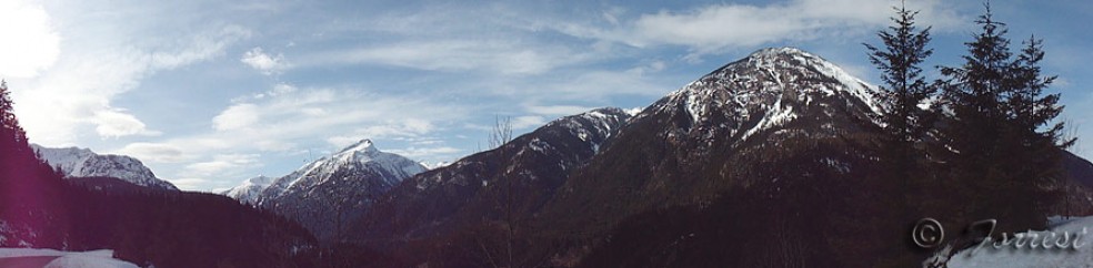
Toward the beginning of the ride, as you come into the Icicle canyon, it looks like it could be some lost part of Colorado. Soon, though, after passing under the pyramid-shaped massifs, the gates of the Icicle canyon, you’ll realize this could only be the Cascades. The jagged ridge-line looks like the teeth of a prehistoric serrated knife, set up by some malevolent god to tear the ancient clouds apart when the world was still being formed.

Below the Enchantment Lakes, the scenery becomes distinctly Cascadian. Gone are the towering singular peaks, the ones that look like frozen pyramids; they've been replaced by spiny granite ridges.
This past weekend, I took my bike over Steven’s Pass to ride the Icicle. I’d heard that the road was snowed out 11 miles in, so, to get a bit more exercise in, I parked on Route 2, about 7 miles from Leavenworth, and rode down through the Tumwater Canyon.
You won’t see any pictures from that area in this post, partly because I’ve already shown you what it looks like, but, more importantly, because Icicle Creek and the mountains that line its canyon are dramatic enough to fill this page. But keep Leavenworth in mind; if you decide to visit, it’s a nice place to explore.

A wide, still snowy couloir in the southern ridge, looking toward the Alpine Lakes Wilderness.
As you ride into the canyon, the first few miles are developed, with houses, school bus stops, and the trappings of modern society. Quickly, you cross into the national forest land. Soon, the only developments are trails leading up the mountains, and small pull-outs for hikers to park in. If you’re especially ambitious, and equipped for touring, you might think about stopping for a mid-ride hike.

Mountain after mountain, leading up into the Enchantment Lakes section of the Alpine Lakes Wilderness Area. The Enchantments in particular and the western ALW are known for their brightly colored (in the fall) larch and maple trees, their austere beauty, and for the common feeling that the ice age just ended yesterday.

A small dirt turn-off next to the road overlooks the Icicle, with peaks towering overhead. The snow is retreating quickly. Unfortunately, I wasn't the only one enjoying the scenery that day.
Ansel Adams said that he was happy if he got one good photo every month, or even ten in a year. Famously, he told people not to expect to produce miracles with every roll of film (anyone remember film?), or even every month.
I used to do a lot of landscape photography, but, sadly, haven’t shot anything good for a while. I came away from this trip with 26 photos I was proud of. Putting this blog post together has been a challenge, mostly because it’s nearly impossible to decide which ones to show, and which to cut. It’s even more difficult because this isn’t strictly a photography blog; I’m trying to give people a sense of what it’s like to ride a bike here.

Icicle Creek runs to the right, and down, in this photo; away from the creek, the trees are getting sparse. There's more snow on the peaks, and closer to the road now, because the road climbs, slowly, to higher ground.

Icicle Ridge, from deeper into the canyon. I can't explain why I like this picture, or why the scene in real life impressed me so much. To try, I would babble something about the stark contrast between the rocky barrens and the lush forest ... but the truth is you should come here and see it for yourself. And then tell me, if you figure it out.
Several kinds of wildflowers were already blooming, and this section of the road was home to more lupines than I could ever hope to count.

Icicle Creek Road was bare until around mile 12, where patches of snow creep inward from the sides of the road, and closed half a mile later. Unlike a similar shot from Teanaway, this really is the end of the road for wheeled vehicles. For now.

This seems to be my favorite image from the trip. Here is the snowy Stuart ridge line, one peak after the next, with needle-like crags, melting snow fields, and, closer, an east-side Cascade forest.
Ask a few people about the Icicle area, or The Enchantments, and “austere beauty” is a phrase you’ll hear over and over again. I think the next photo gives a hint at what people are talking about, although, for hikers and craggers, the world becomes much drier and rockier as you climb the ridges.

The remains of what used to be two trees, with the Icicle swirling around them. I like this image because the silver branches, the rightmost ones, look like a fire, frozen in time by the icy water.
As with other ride reports, I’ll describe the route I followed, and you can adapt it to your schedule and taste. I think the pavement goes about 15 miles, but I’m not certain. It’s currently snowed out at 12. If you want to ride longer, start the ride farther away.
- I parked in the picnic area on US 2, 7 miles up the mountain from Leavenworth.
- From the western side of town, follow Icicle Road. If you’re heading east, as I was, this will be a right turn immediately before the first gas station.
- Follow Icicle Creek Road until its end, or until you feel like turning back.
My Garmin shows 37.7 miles for the trip, with 2,283 feet of elevation gain. About 14 of those miles, and 500+ of those feet were in the Tumwater Canyon.
Be sure to bring plenty of water, and, if it’s a hot day, a purifier would be a good thing to have.


